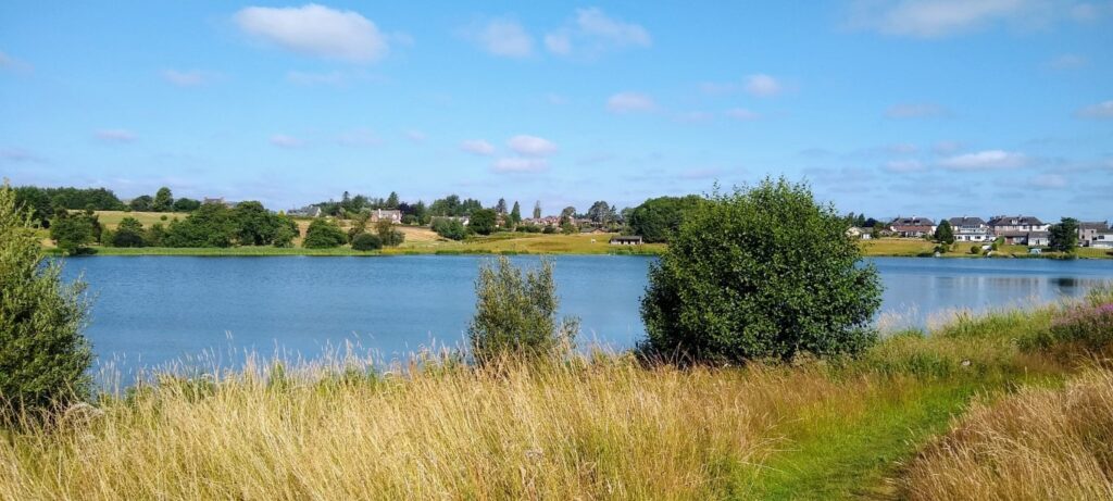
Kirk Loch in Lochmaben offers short but enchanting walks amidst its picturesque surroundings, nestled in the heart of Dumfries and Galloway, this historic site invites visitors to wander along its scenic trails, providing breathtaking views of this tranquil loch. The walks at offer a perfect blend of natural beauty and is an idyllic destination for nature lovers and history enthusiasts alike; and all in the centre of the town!
The Kirk Loch nature reserve is owned and cared for by the local community. Please respect it.
Below are a number of maps of walks around the Kirk Loch, these walks are all relatively easy to do and the selections demonstrate a number of alternative options to extend the routes. Please have a look at the guide,
Using the Map
, for the symbols on the map before using.
Timings for the walks have been calculated in Kilometres loosely based on
Naismith's Rule
with speed of 4 Km / hour.
Walk Description
From the Town Hall (walk south along the High Street on the right or west side and turn right immediately after the baker’s /
café into Well Vennel. In 100 m arrive at the Caravan Site on the shores of the Kirk Loch.
The loch gets its name after the site of the original church which is in the old Churchyard. The tarmac area of the Caravan site
was a public area known as Katie Waugh’s Yard. The Caravan warden’s hut was formerly a Curling Hut–a reminder of colder
winters!
Straight ahead on the skyline, looking south-west, is Beacon Hill, one of a chain of hills from which fires were used to
communicate warnings to different communities.
Continue to the shore of the loch and bear left to the corner where there is a “Public Footpath” sign. Follow this along the side
of the loch with the Lochmaben Golf Course on the left.
Be aware of the danger of stray golf balls on this path!
As you walk along the loch side you will notice the remains of wooden stakes in the water. These are the remains of structures
which were used during World War 2 when forces stationed at Halleaths Camp made extensive use of the lochs for military
training and manoeuvres in preparation for the D- day landings.
After 600 m turn slightly right onto a broader path through a small wood beside a stream, the Vendace Burn, flowing out of the
Kirk Loch. In the far corner of the Golf Course go through a gate. Turn left on a path which rises between the Golf Course and a
field and in 180 m reaches a gate and a road at Castlehill Farm.
Turn right and pass in front of the farmhouse and continue through a gate onto a grassy path between two fields. This path
descends slightly and bears left to reach a gate on the B7020 Lochmaben-Dalton road. Cross the road and through another gate
and almost immediately reach the Castle Loch path. At this point, there is the alternative of going right to continue around the
Castle Loch visiting Lochmaben Castle and a Bird Hide.
Turn left here and follow this for 850 m until it reaches the B7020 again. This path is in the Castle Loch Local Nature Reserve
and is also part of the Sculpture Trail. There is a viewing area over the loch with an information board. To return to the Town
Hall turn right, in front of the Bowling Green to the side of Castle Loch and then turn left through Victory Park to reach the High
Street.
Credits: Paul Gow, Tom Russell and David Mair of the Lochmaben Initiative and Robert Togneri for editing and production,
Walk Description
From the Town Hall (walk south along the High Street on the right or west side and turn right immediately after the baker’s / café into Well Vennel. In 100 m arrive at the Caravan Site on the shores of the Kirk Loch.
The loch gets its name after the site of the original church which is in the old Churchyard. The tar-mac area of the Caravan site was a public area known as Katie Waugh’s Yard. The Caravan warden’s hut was formerly a Curling Hut–a reminder of colder winters!
Straight ahead on the skyline, looking southwest, is Beacon Hill, one of a chain of hills from which fires were used to communicate warnings to different communities.
Continue to the shore of the loch and bear left to the corner where there is a “Public Footpath” sign. Follow this along the side of the loch with the Lochmaben Golf Course on the left.
Be aware of the danger of stray golf balls on this path!
As you walk along the loch side you will notice the remains of wooden stakes in the water. These are the remains of structures which were used during World War 2 when forces stationed at Halleaths Camp made extensive use of the lochs for military training and manoeuvres in preparation for the D- day landings.
After 600 m turn slightly right onto a broader path through a small wood beside a stream, the Vendace Burn, flowing out of the Kirk Loch. In the far corner of the Golf Course go through a gate. Turn left on a path which rises between the Golf Course and a field and in 180 m reaches a gate and a road at Castlehill Farm.
Turn right and pass in front of the farmhouse and continue through a gate onto a grassy path between two fields. This path descends slightly and bears left to reach a gate on the B7020 Lochmaben-Dalton road. Cross the road through another gate and almost immediately reach the Castle Loch path. Turn right on the Castle Loch path. Stay on the path until you reach a gate onto the Lochmaben Castle Road, turn left and follow the road and turn sharp left shortly after the entry to Castlemains Farm. Some 40-50 m from this bend there is a sign to a wooden sculpture of Robert the Bruce carved in an old tree on the left–this is the last sculpture on the Sculpture Trail. Further on the left is a “Robert the Bruce Trail” information board and later another board describing the history of the castle, before you reach the more extensive main car park.
To continue the walk to the Bird Hide take a path from the small car park on the right, opposite the Bruce Trail Board. The path descends slightly to reach a raised wooden walkway. After a short distance, the walkway leads to the Bird Hide on the left. The walk continues straight ahead and over a bridge crossing the Valison Burn. Continue by going right for 60 m and then left following the path into Kirkhirst Plantation.
Just after you exit Kirkhirst Plantation turn right and go through the metal gate to the edge of the A709 Dumfries – Lockerbie Road –take care here you are on a busy road with fast traffic – and take the side road signposted to Halleaths. Continue on this road for 320 m and then turn left on the road leading to Lochmaben, passing Innerfield Farm. The road turns left over a bridge which crossed the former Lockerbie-Dumfries railway.
The railway was originally part of the Caledonian Railway and was opened in 1863. Sadly the line was axed by Dr Beeching and closed in 1965. Milk was transported from Lochmaben to Edinburgh by rail to supply the Edinburgh Dumfriesshire Dairies. In the city the deliveries were by horse-drawn floats or latterly electric float lorries.
Credits: Paul Gow, Tom Russell and David Mair of the Lochmaben Initiative and Robert Togneri for editing and production